Today, Cerexio investigates the impact of capitalising on satellite data to feed the expanding population and meet the insatiable demand for food resources around the world. In brief, food insecurity has led to the suffering of millions of people around the world, but the healthy and tactful usage of EO (Earth Observation) data can reduce the number of people facing a food crisis and provide enough insights to mitigate the shortage of food.
Impacts of Food Insecurity and Food Crises
Food insecurity and instability can lead to the malnutritions that fatally threaten livelihoods, exhaust the savings of massive amounts of people, and mismanagement of livestock upkeep, crops and medicine. There are 5 phases of food insecurity, starting from the nutritionally gratified communities to communities that are fatally malnutrition. Namely, these phases are: Stable, Stressed, Crisis, Emergency, Famine (or Catastrophe). Acute malnutrition leads to communities making desperate decisions like selling essentials to bring food to the table, or migrating and working under merciless suppression, or even selling their own children- which leads to people questioning the ethicality behind their decisions. However, the worst-case scenarios lead to malnutrition-related illnesses, destitutions, starvation and death.
Some of the countries that faced the peak of the food crisis in 2020 are Congo, Yemen, Afghanistan, Syria, Sudan, Nigeria, Ethiopia, Sudan, Zimbabwe and Haiti.
Why is Satellite Data Unmissable?
HLPE (The High Level Panel of Experts on Food Security and Nutrition)- the interface of the CFS (UN committee researching on World Food Security) elaborates the recent impacts that led to the rapid rise of hunger and malnutrition at a global scale. One of their researches illustrated how the dynamics rooted after the advent of COVID-19 led to rising threats for nutrition and security of food resources. The illustration below was shared in this report to address how the 2020 socio-economic realities were not only suffering from the epidemic but also a malnutrition and hunger pandemic.
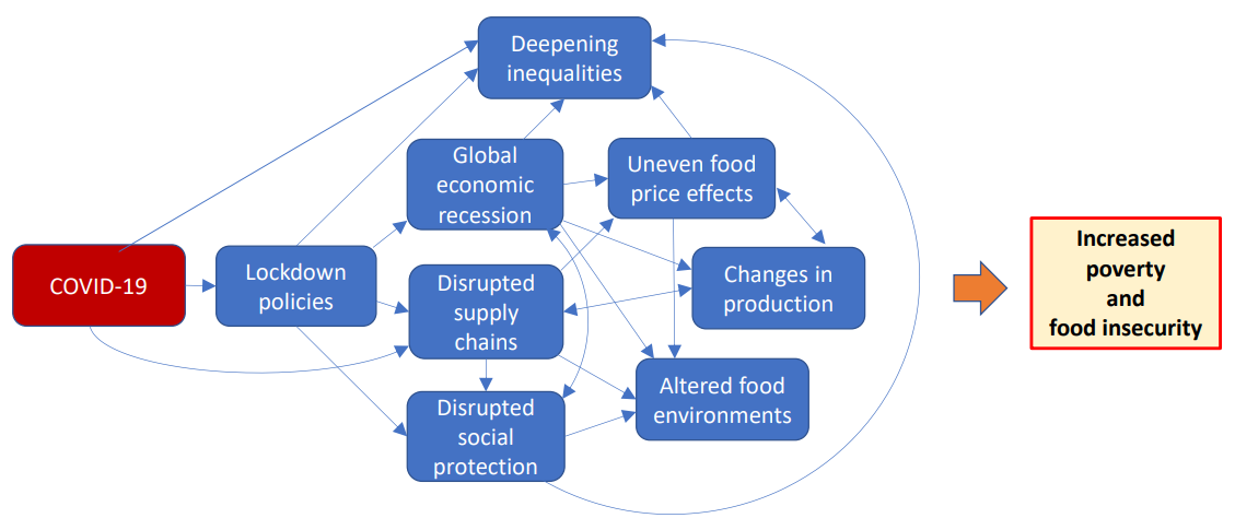
- political decisions,
- economic recession,
- augmented food environments,
- societal inequities,
- efficient social protection strategies, and
- the increase of localised food prices,
are a few reasons for this detrimental situation. However, one of the most impactful threats is ineffective changes in production. It explains how horticultural production would meet production shocks due to the shortage of labour and inability to determine the production supply requirements accurately- like transportation of seeds, amounts of seeds, fertiliser quantities and more. This is where the need for Satellite Data is unmissable.
How Does It Work?
Satellite data, when combined with AI and ML models, offer permanent solutions to the most pressing issues in the global food crisis. It didn’t take long for most agricultural specialists and national decision-makers to understand that the satellite is the ultimate risk mitigation, visualisation, and analytical tool to ensure healthy and reassured food production. EO data offers real-time web-based tools that can be used by people to access satellite and ground data to make robust, efficient and real-time agricultural decisions despite the changing weather conditions, environmental impacts and spontaneous changes in the food demands across the globe.
Satellite Data can also work in collaboration with other technologies like IIoT-driven Drone (UAV) Systems, GIS Layers, Predictive Analytics, Prescriptive Analytics, Digital Twin and Simulation and a range of other new-age technologies to offer immersive and interactive experiences to understand the actualities of food production. With such futuristic collaborations, satellite data can offer hyper-local evaluations, predict impending crop health and threats, understand future location-sensitive weather and growth changes before they materialise, get comprehensive evaluations of biomasses in farming areas and more.
Benefits of Using Satellite Data in Food Production?
Satellite Technology ensures that the altered food environments and changes in production are done by fact-based insights that are enabled by EO data, which monitors and estimates food production by leveraging remote sensing technologies to manage a crisis before it even occurs. Here are some instances where Satellite Data is deemed to be most beneficial and efficient in the food production sector.
- Analyse the quality of soil fertility, moisture and chemical composition
- Become the ‘Eyes on The Sky’ to manage and control the water supply of agricultural land
- Help developing countries meet SDGs (Sustainable Development Goals), which facilitates dodging food crisis
- Map and offer interactive investigation power of irrigated land in real-time
- Offer data to make simulations and interactive timelines to visualise the growing season progress of mass crops
- Optimally guide fertiliser application roadmaps to ensure all crops (even the hard-to-reach crop patches) are not affected by diseases or pests
- Predict crop yield and measure it against the demand for food to understand the food security rates of a country
- Predicting weather changes and other natural phenomena like landslides, droughts, bushfires and other hazards that impact crops
- Space-based crop health monitoring lenses to ensure the sustenance, healthiness and resilience of crops throughout the food production lifecycle
Is Cerexio A Part of This Mission?
Cerexio offers a range of new-age technologies empowered by satellites to ensure that the agricultural operations and leveraging the maximum out of AI are optimally carried out. We tailor software stacks that are web-based tools and applications that agricultural expert agronomists and farmers. You can use these technological solutions to leverage satellite data and manipulate them using smart AI, and IIoT powered analytical tools to get actionable insights on risk mitigation plans and strategies to facilitate agricultural decisions. We also offer the best visualisation tools to get comprehensive visibility on crops and their sustainment requirements via new-age technologies like GIS layers, Digital Twin, Simulations, Smart Dashboards and more. Connect with Cerexio to learn more about our solutions and services that mitigate the risks of Food Insecurity and Instability.
Future Implications of Satellite-based Anti-Crisis Measures
Compared to most technologies, satellite technologies have supported critical national decision making that relates to food production and supply; it ensures countries shore up the rates of unhindered food security in most countries. Therefore rather than relying on conventional and operationally limited methods of agriculture, farmers, agricultural specialists, agronomists, and governmental establishments now look up to the skies to harness the power of satellites. Satellite technologies have the potential to help decision-makers give a deadline to global hunger and malnutrition by deploying sustainable food production solutions that will use fact-based analysis to increase the productivity of food.