GIS technology uses the integration of big data to understand the fundamental principles of geography and how they can affect an organisation in terms of operations, stakeholder relationships, management and other important functions. Today we will be understanding this location-oriented analytical tool and how it can optimise organisations of the digital age.
A Brief History of GIS
In 1982, Jack Dangermond- who is also known by the title ‘The Father of Modern-day GIS’ engineered the first GIS technology for commercial purposes- ARC/INFO. This is the first scalable and modular software to enable location-specific information which is accessible across organisations- this was the stepping stone for ArcGIS- an online GIS service provider maintained by Esri.
However, the concept of using geographical information to solve problems dates back to 1854, when Dr John Snow used the power of maps to identify and track the patterns of a historic cholera outbreak that allowed him to pinpoint the source of the epidemic. Cholera is a fatal airborne disease with very high mortality that took an average of 600 lives a week at Regent Street, Soho, London, during the month of September in 1854. Even though the third industrial revolution- or the emergence of computers- was far ahead, Dr John Snow managed to think ahead of time and use geolocation points to investigate the impact of the outbreak and how to control it.
Dr Snow used geographic information to save millions of lives by using maps to understand a situation, tailor an event-driven plan and make the latest decisions. He is one of the classic examples that elaborate on how important GIS technology is, especially when we are facing a similar epidemic situation in 2021.

Why is GIS Technology Important?
The Timeliest Visualisation
Give Better Meaning to Big Data
A Comprehensive Tool for Environment Engineers
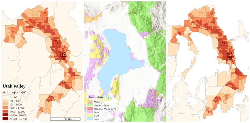
GIS Maps can visualise where the storms, tornados and hurricanes are brewing, where floods are raging and when and where soil erosions occur and how to mitigate risks in areas that are majorly disaster-prone. GIS technology can power up spatial support systems with maps that illustrate weather changes, demographic data, human-made environmental hazards and other influences to anticipate natural disasters. For example, Google Earth uses 3D-GIS to monitor flood disasters. Google Earth Pro Version 5 offers a cost-efficient web-based monitoring system to estimate inundation zones, disasters and water depths with easier integration with KML (Key-hole Markup Language) and GIS files.
Say No Lengthy Databases
Cerexio GIS Technology- The Unrivalled GIS Solution Enablers In Singapore and Australia
- Our GIS maps are powered by AI models that can be tailored to meet unique insights requirements and can also be linked to early warning detection systems to help your decision-makers and active risk mitigation specialists take prompt responses to solve problems.
- Our GIS technology allows commercial and industrial organisations to empower their operations, administration and management and push their organisations to the competitive edge by capitalising on location intelligence.
- Global leaders can use Cerexio GIS to focus on the dynamic climatic events and use GIS maps as a foundational technology to isolate disaster-prone areas to ensure the wellbeing of the community and natural resources across cities, states and countries.
- Cerexio can also build ArcGIS maps to help government leaders to understand the past, present and future behaviours of the COVID-19 virus in their country and scale the maps based on the virus’ variants (i.e. Beta, Gamma, Delta, Omicron) to understand how, where and when did the virus spread and root out sources to mitigate national epidemic risks.
- Cerexio Technology also allows GIS maps to be empowered with EO (Earth Observation) data extracted by satellites to create imagery with remotely sensed data and more.
GIS is Dominating The World
Many industries- media, public sector, real estate, commercial and many more- are already using GIS on a large scale. The features and tools enabled by GIS technology are indispensable and result in promoting tangible benefits for most. GIS maps are the maps of a better future, and they will keep getting advanced, more comprehensive and easier to use in future. This is why if your organisation is lagging in meeting its desired goals you should consider adopting GIS software to pinpoint the hidden opportunities and strengths of your organisation, and we can help you there.